Resources
We love technology at Water Solutions, at the heart, we are powered by all sorts of high-end technologies for all of our operations. Some may say that we are a technology company now, below is an overview of the different technological equipment we have at our disposal for any project that you may present us with.

Vessel
Survey Vessel - WS Moresby
WS Moresby is a custom-designed survey vessel that boasts ample deck and cabin space for our survey operations as well as equipped with mounting points for a full MBES system. The draft of this vessel is only 0.4m, making her perfect for coastal surveys. WS Moresby can operate in conditions of up to 2m of waves, however we will carry out survey operations in 1.5m of waves to keep our work within the range of good practice.
Click Here for full technical specifications.

Teledyne Odom MB2
No. of units: 1
The MB2 Multibeam Echosounder is developed for fast mobilization on smaller vessels and is optimized for shallow water survey companies, Port and Harbour Authorities, dredging companies and other users looking for an easy to use, quick to deploy, high resolution system. MB2 is capable of sounding a swath of up to 140° in up to 110m of water depth,.
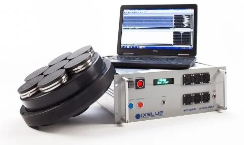
iXBlue ECHOES 10000 Sub Bottom Profiler
No. of units: 1
iXBlue ECHOES 10000 is an ultra high resolution sub bottom profiler designed for shallow water environments. It incorporates iXBlue flat spectrum Tonpilz ceramic transducers allowing unrivaled data delivery. Together with DELPH Seismic Acquisition, it is a full feature survey tool with DELPH Interpretration high-productivity software, enabling missions to be achieved successfully and effortlessly.

Valeport SWiFTplus Turbidity SVP
No. of units: 1
Designed from the outset with the intention of a seamless workflow, the SWiFT SVP has integrated GPS to geo-locate every profile. SWiFT SVP features high accuracy SV, Pressure and Temperature, re-chargeable battery, LED status indications for GPS, battery and communications.

Valeport MiniSVP
No. of units: 1
The miniSVP is a new budget Sound Velocity Profiler, designed to make the best Sound Velocity measurements in the world available to everyone.
Featuring Valeport's unique acclaimed "time of flight" SV sensor, the miniSVP is available in either 500m rated acetal or 6000m rated titanium versions. A single C cell and large Flash memory allow hundreds of profiles to be recorded, and the pre-programmed profiling patterns allow it to be setup and deployed quickly and easily.

Valeport TideMaster Tide Gauge
No. of units: 2
the TideMaster is a small, cost effective Water Level Recorder, specifically designed for applications where the user requires an accurate record of water height, but with the added option of meteorological data via an ultrasonic wind speed and direction sensor.
Suitable for use in fresh or salt water, the TideMaster can be deployed for up to 1 year, dependant on the sampling rate, with instrument set up and data retrieval via an optional display panel or using the PC software supplied.

Aquadopp Profiler 400 kHz
No. of units: 1
The Aquadopp Profiler is a highly versatile Acoustic Doppler Current Profiler (ADCP) available in four profiling range options, from < 1 m to > 85 m. Designed for simple yet powerful operation, this current profiler is packed with features used by engineers and researchers to enable accurate and effective hydrodynamic data collection in a variety of environmental conditions.

RBRduet³
No. of units : 2
Compact Loggers: Small size, big capacity. The RBRduet³ series are most compact, lightweight, and versatile loggers. Equipped with big storage capacity and USB-C download, they are optimized for long deployments with high sampling rates.
Tide & Wave Measurement
Any AA battery
Up to 30M measurements
Up to 32Hz sampling (optional)
USB-C download
Flexible measurement schedules

Terrestrial Laser Scanner
Leica BLK 360
No. of units: 1
This amazing laser scanner is small enough to fit in your hand but powerful enough to deliver full 360° reality capture in under 3 minutes. Leica have developed the BLK360 to bridge the gap between scientific-grade 3D laser scanners and emerging camera and handheld technologies. With max range of 30m.

SinoGNSS ComNav Technology M300 Pro GNSS Receiver
No. of units: 2
The M300 Pro is able to track all existing and future GNSS constellations including GPS, GLONASS, Beidou (B1, B2, B3), Galileo and QZSS. There is no doubt that the M300 Pro is always keeping pace with GNSS development, which provides a robust and future-proof GNSS solution for CORS.
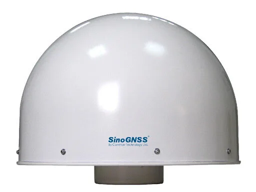
SinoGNSS AT500 Choke Ring Antenna
No. of units: 2
The AT500 is a high performance choke ring antenna that can track GPS L1, L2C, L2P, L5, GLONASS L1, L2, BeiDou B1, B2, B3, Galileo E1, E5a/E5b, AltBoc, L-Band and SBAS. It is specially designed for deformation monitoring, CORS, and related GNSS infrastructure networks. some of its features include:
Low Noise Amplifier and high gain
Sub-millimeter level phase center error with outstanding stability and repeatability
Strong capability of tracking satellites at low elevation angle
Superior water and dust-proof design

Robotic Total Station
Leica Viva TS16
No. of units: 1
Leica Viva TS16 Total Station automatically adjusts to any environmental conditions, locking on to only your target and ignoring other distractions. No matter how challenging your task is, this smart total station continues to exceed expectations. Cover a variety of applications with the TS16 seeing just what you see. With the most comprehensive imaging capabilities available, you can capture exact conditions for any jobsite with the self-learning capability of this total station. TS16I is configurged as one man systems that utilise the new Leica Captivate CS20 Controller.

GNSS RTK Rover
Leica Viva GS18 T
No. of units: 4
The GS18 T GNSS RTK rover is part of the Leica Geosystems self-learning GNSS series. It seamlessly combines with Leica Captivate field software and Leica Infinity office software, continuing the powerful and immersive Leica Captivate Experience. This latest innovation combines GNSS and inertial measurement unit (IMU) being the first true tilt compensation solution that is immune to magnetic disturbances and is calibration-free. The GS18 T works directly out of the box.
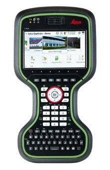
Leica Captivate Controller and Captivate App
Leica CS 20
No. of units: 4
The Leica CS20 controller offers a robust design and high performance, providing the ultimate in control and convenience with complete mobility. Touch screen technology allows you to process data while a stunning 3D view transforms your Leica Viva GNSS and Leica Nova scanning experiences.

Leica Viva GNSS Receiver
Lecia GS 15
No. of units: 3
The GS15 uses SmartCheck with RTK data processing to guarantee correct results. Its SmartTrack system uses four constellations tracking of all current GNSS satellites and it has the capacity to encompass new satellite developments too. Meanwhile, SmartRTK will deliver you quality results in all networks.

Leica Viva Controller and Smart works app
Leica CS 15
No. of units: 3
Designed for extreme environments, you can always rely on your CS15 and CS10 field controllers. They are comfortable to hold and easy-to-use, making them your perfect partner on site.The Viva CS15 and CS10 controllers are perfectly designed to be used with SmartWorx Viva surveying software. With clear graphics, practical menu structures, understandable terminology and simplified workflows, save time and effort on any site. SmartWorx Viva is incredibly easy to learn and use. You and your field crew will be up to speed in no time.
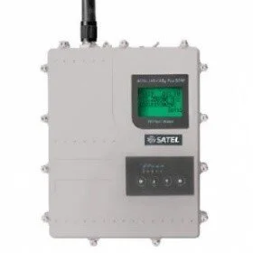
Long Range Data Radio
Satel Easy pro 35w
No. of units: 1
SATELLINE-EASy Pro is an IP67 classified UHF radio modem with a high power transmitter, a wide 70 MHz tuning range and selectable channel spacing. It is particularly well suited for outdoor use under varying weather conditions, e.g. land surveying. Due to the high transmitting power, connection distances of up to 80 kilometers can be covered.
Long Range Data Radio
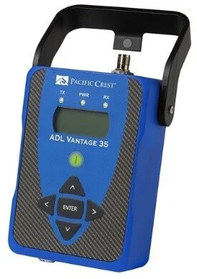
Pacific Crest ADL Vantage 35
No. of units: 3
ADL Vantage 35 is an advanced, high speed, high power, wireless data link built to survive the rigors of GNSS/RTK surveying and precise positioning. This sophisticated 2 - 35 Watt radio modem utilizes Pacific Crest’s next generation Advanced Data Link (ADL) technology while remaining backward compatible with existing Pacific Crest

Auto Level
Topcon Auto Level (AT-24A)
No. of units: 3
Topcon’s AT-24A Automatic Level is ideal for construction and surveying contractors who demand the highest levels of accuracy, reliability and robust performance
Unmanned AERIAL VEHICLE (UAV)
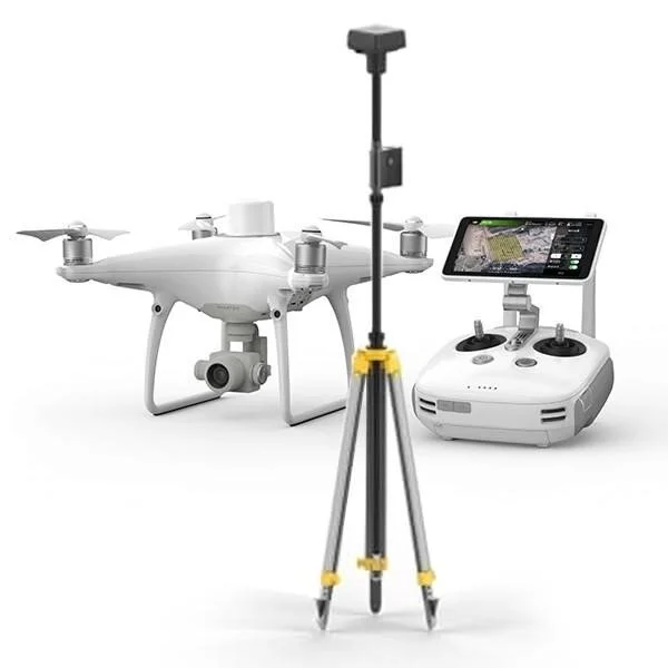
DJI Phantom 4 RTK
No. of units: 2
Phantom 4 RTK has the ability to capture centimeter-accurate data while requiring fewer ground control points. A new RTK module is integrated directly into the Phantom 4 RTK, providing real-time, centimeter-level positioning data for improved absolute accuracy on image metadata. Sitting just beneath the RTK receiver is a redundant GNSS module, installed to maintain flight stability in signal-poor regions such as dense cities. Combining both modules, the Phantom 4 RTK is able to optimize flight safety while ensuring the most precise data is captured for complex surveying, mapping and inspection workflows.
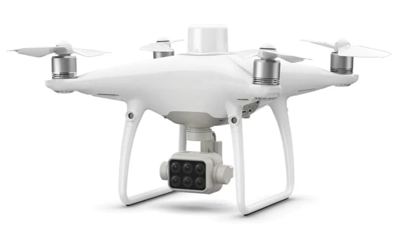
DJI Multi Spectral RTK Drone
No. of units: 1
Multi Spectral imagery collection is now simpler and more efficient than ever before with a built-in stabilized imaging system that collects comprehensive data sets right out of the box. Access information collected by 1 RGB camera and a multispectral camera array with 5 cameras covering Blue, Green, Red, Red Edge, and Near Infrared bands – all at 2 MP with global shutter, on a 3-axis stabilized gimbal.
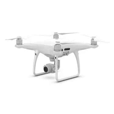
DJI Phantom 4 Pro
No. of units: 2
Industry leading drone that has proven to be reliable, both in its software and hardware can be used for areal photography and for observation of large areas.

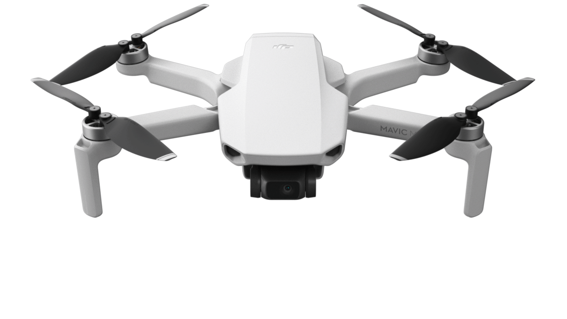
DJI Mavic Pro
No. of units: 1
The DJI Mavic Pro is a small yet powerful drone with a 24 high-performance computing core processor, an all-new transmission system with a 4.3mi (7km) *range,5 vision sensors, and a 4K camera stabilized by a 3-axis mechanical gimbal.
DJI Mavic Mini
No. of units: 2
Weighing just 249 grams, Mavic Mini offers a 30-minute flight time, 4km HD video transmission, and a 3-axis gimbal with 2.7K camera, the Mavic Mini is perfact for quick site observations and photography,

WingtraOne QX1 PPK
No. of units: 1
The WingtraOne VTOL mapping drone is capable of performing fast aerial surveys across wide or hard-to-reach areas and producing reliable maps with unparalleled resolution and accuracy.
In one flight, WingtraOne can map almost 2x more than a conventional fixed-wing drone and approximately 10 to 15x more than multicopter drones. Combine VTOL, the powerful Sony RX1RII 42 MP full-frame and a PPK module from Septentrio, and you get accuracy that was previously only possible with land survey equipment.

Nctech iStar Pulsar+
No. of units: 1
iSTAR Pulsar+ compact mobile mapping system provides industry-leading 11K 360° imaging in an accessible form. With built in GPS and local Image processing and IP64 certification, it is the best in class for any application that utilizes 360 imaging.

Aeroqual Series 500 - Portable Air Quality Monitor
No. of units: 1
The Series 500 air quality sensor enables accurate real-time surveying of common outdoor air pollutants, all in an ultra portable handheld monitor. Air quality professionals typically use the Series 500 for short term air quality studies and carrying out checks on pollution “hot spots”. The Series 500 can also be deployed for short term fixed monitoring by adding an optional outdoor enclosure.

GNSS Processing Softwares
Leica Infinity
Leica Infinity: a user-friendly, intelligent software platform with intelligent information architecture that opens up previously unimagined possibilities within many aspects of your workflow. More efficiency, greater transparency and simply better.

Leica Geomatic Office (LGO)
Leica Geo Office - one integrated Office Software. One Office Software for all your instruments. Leica GeoOffice. Get best results by managing and combining your data with Leica Geo Office.
Leica Cyclone Register 360
Leica Cyclone REGISTER 360 is the latest upgrade to the number one point cloud registration software, Cyclone REGISTER. This all-new product built from the ground-up brings with it all-new capabilities from simple, guided workflows to automated registration and client-ready deliverable with the click of a button.
Licensed for
Leica Cyclone REGISTER 360
Leica Jet Stream Server
Leica Trueview Publisher
Leica Jet Stream Publisher
Leica CloudWorx for Autocad
Leica Jet Stream connector
Image Processing
Pix4D Mapper
Pix4D is a suite of software products that use photogrammetry and computer vision algorithms to transform both RGB and multispectral images into 3D maps and models

Teledyne PDS Hydrography
Teledyne PDS is a software package for hydrographic survey and dredging operations. It offers modules that cover the entire operation from acquisition to the end product.
Pano2VR
Pano2VR is a powerful software that converts your panoramic or 360° photos and videos into interactive virtual experiences.
Apart from those listen above, Water Solutions utilizes a variety of smaller resources to provide its customers with the best in class service in all fields.