
Geographic Information System (GIS)
Geographic Information System is a system designed to capture, store, manipulate, analyze, manage, and present all types of geographical data. The acronym GIS is sometimes used for geographical information science or geospatial information studies to refer to the academic discipline or career of working with geographic information systems. In the simplest terms, GIS is the merging of cartography, statistical analysis, and database technology.
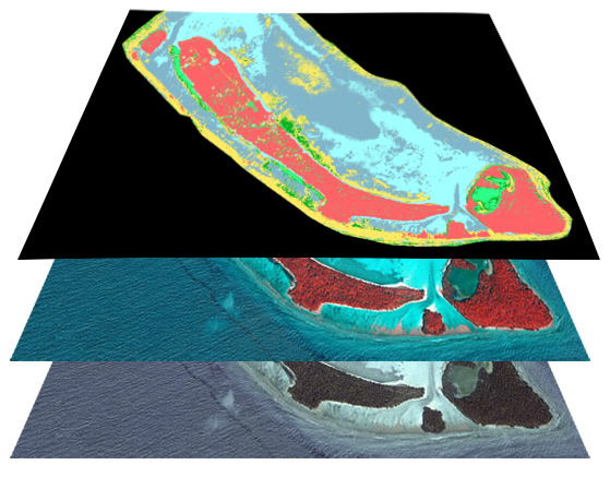
GIS is mostly used to handle a wide range of data sources such as aerial photo, satellite imagery, topographic maps, bathymetry, lidar, DEM, etc. The data is analyzed together in layers to find solutions to issue.
Application of GIS
Some of the applications of GIS are:
Flood modeling
Cadastre- Land Management
Cartography
Multiple Criteria Decision Analysis
Geostatistics
Topological Modeling
Geometrical Modeling
Controlling Outbreaks.
Environmental Monitoring
Planning and Design Built Environments
Change Detection
Sustainable Development
Land Tax Management
largest database in maldives
Water Solutions has the largest and most up to date GIS data bases which includes various layers of data. These include:
Island and atoll boundaries.
Bathymetry
Administrative boundaries