
Numerical Modelling
Coastal areas of dynamic small islands
In Environmental engineering, different methods of numerical modelling can be used to analyze the changes that occur in the environment, In environmental modelling, the processes that pout in the real world are represented as accurately as possible. Dynamic models can be used to analyze how the environment changes in a given time period due to certain manmade or natural factors.
Introducing MIKE 21

Water Solutions Pvt Ltd Became the first company in Maldives to introduce numerical modelling using one of the most popular and well known scientific modelling software’s MIKE 21. Currently numerical modelling is being used to provide input variables required by simulation models and yield visualization and analysis of output data. With the vast amount of data available at Water solutions, the models created become more accurate.
Environmental modelling using cloud computing technology is focused on spatiotemporal data analysis and modelling. Various simulation tools together with GIS are used to demonstrate modelling of surface water pollution, spatiotemporal analysis of air pollution data, and modelling of erosion and formation of beaches. The cloud computing environment helps to manage modelling tasks and spatiotemporal analysis.
A step by step guide to our process
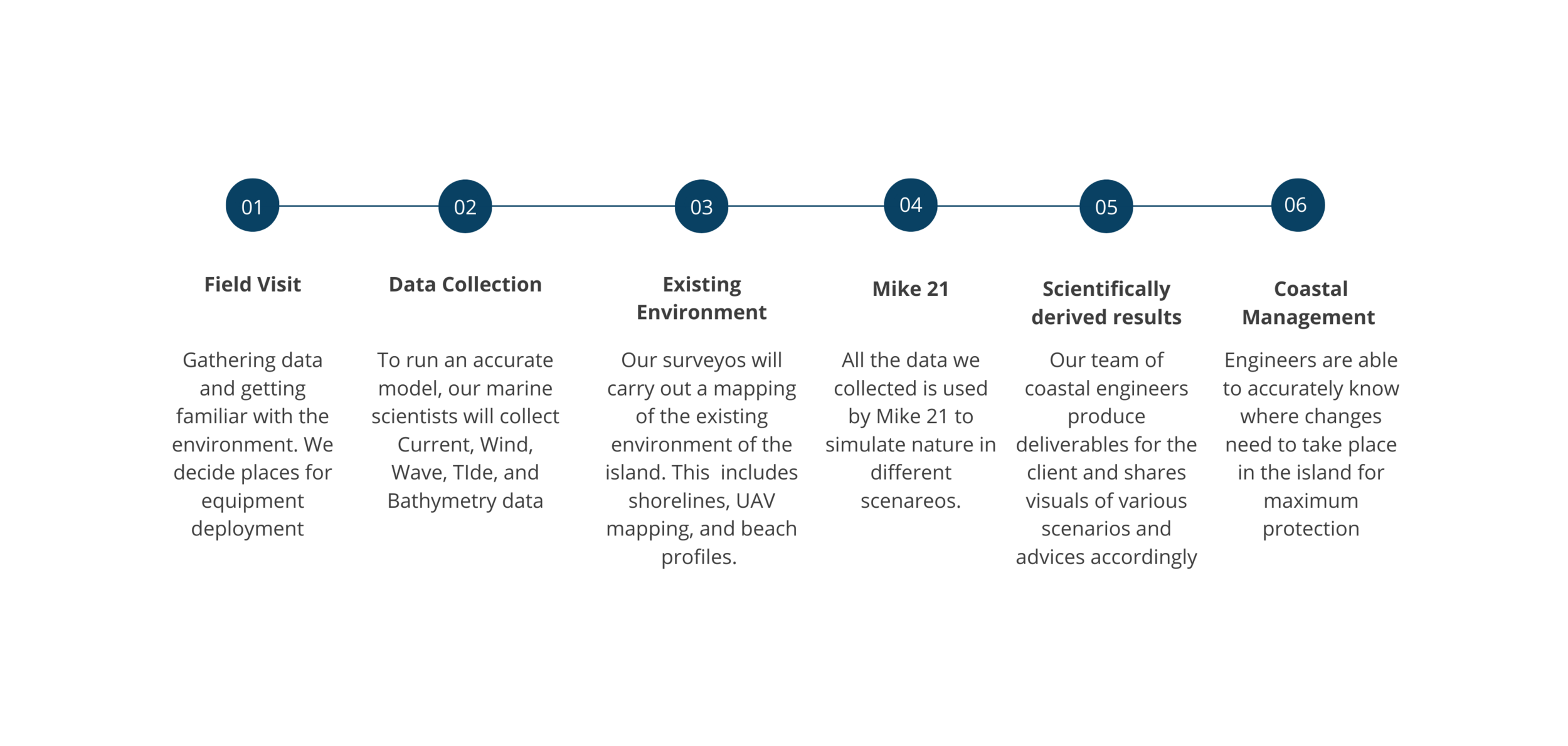
Endless scenereo’s backed with accurate data
Spectral Waves FM with coastal protection
Spectral Waves FM without coastal protection
The MIKE 21 SW wave model is a cutting-edge solution for simulating wind-generated waves and swell in offshore and coastal areas. Utilizing unstructured meshes, hind-cast data and a flow model, the model is able to accurately predict the growth, decay, and transformation of waves for both the Southwest and Northeast monsoons. By comparing simulations before and after coastal protection measures are implemented, we are able to provide our clients with the most cost-effective and long-term solutions for protecting their island's shoreline. This approach is scientifically derived and proven to be the best way to protect the island and its infrastructure.
Sediment Transport Model with coastal protection
Sediment Transport Model without coastal protection
The sand transport module calculates the resulting transport of non-cohesive materials based on the mean horizontal flow conditions found in the hydrodynamic calculations and if included wave conditions from wave calculations. This model is coupled with the flow model and the wave model to create an integrated sediment transport model. We are able to accurately visualize the movement of sediment before and after different measures have been taken in both monsoons. Using sediment transport models we are able to confidently advice our clients on exact measures to be taken during both southwest monsoon and northeast monsoon saving them precious time and money.
Flow Model FM with coastal protection
Flow Model FM without coastal protection
MIKE 21 Flow Model FM is a modelling system based on a flexible mesh approach. The modelling has been developed for applications within oceanographic, coastal and estuary environments. Coastal modelling is divided into three sections. The first section is the Hydrodynamic flow model (FM). The flexible mesh and the hind-cast data will be used to run the flow model accurately, for the Southwest monsoon and the Northeast monsoon. This allows us to further improve the accuracy of our outputs and deliverables for our clients.
“To my knowledge, This is the best modeling suite and the strongest component of which is the speed of model set up and pre and post processing”